| Home > Theses > Characterisation of the Palaeozoic Basement Geometry in the Melantois-pevele Region (Northern France) From the Horizontal/vertical Spectral Ratio (Hvsr) Method: Implications for Geothermal Energy and Regional Investigations |
| Home > Theses > Characterisation of the Palaeozoic Basement Geometry in the Melantois-pevele Region (Northern France) From the Horizontal/vertical Spectral Ratio (Hvsr) Method: Implications for Geothermal Energy and Regional Investigations |
Master thesis supervised by Graveleau, Fabien; Van Noten, Koen; Lecocq, Thomas; Chanier, Frank; Bossennec, Claire; Watremez, Louise (Université de Lille)
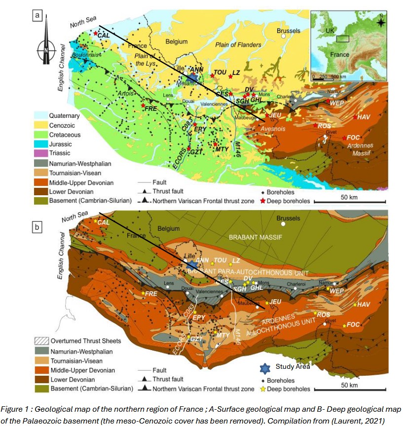
Abstract: In northern France, understanding the subsurface geology characterized by a Meso-Cenozoic sedimentary cover several tens to hundreds of meters thick, unconformably overlying a Palaeozoic basement, is crucial for both resource management and risk assessment. This includes applications related to geo-resources (e.g., hydrogeology, geothermal energy) as well as geohazards (e.g., cavity collapse, seismic hazard). To support these objectives, we applied a passive seismic geophysical approach across the contiguous regions of the Lille Metropolitan area and Pévèle (northern France) to accurately determine the depth of the Palaeozoic basement. This method is based on the Horizontal-to-Vertical Spectral Ratio (HVSR) of ambient seismic noise, primarily generated by anthropogenic sources. It enables the identification of a fundamental resonance frequency (f₀), which is empirically related to the thickness (h) of the overlying sedimentary cover through a power law equation. This empirical relationship was calibrated using 37 boreholes from the French Geological Survey’s (BRGM) Subsurface Database (BSS), where the depth to the Palaeozoic basement is precisely known (ranging from 30 to 200 meters). The best-fitting power-law model derived from this calibration is: h = 196.426 ⋅ f₀⁻1.334, with a prediction error estimated at 10–15%. Beyond the main resonance peak which is associated with the full thickness of the Meso-Cenozoic cover, a second with shallower resonance peak was observed in many HVSR measurements across the Lille rban area. This secondary peak is likely related to the phosphatic hardgrounds ("Tuns") found within the Turonian–Coniacian chalk formations. While this signal may allow for an indirect estimation of the depth of these hardgrounds, no reliable empirical relationship has yet been established at this stage of the investigation. The application of this empirical model enables rapid and non-invasive estimation of basement depth in areas lacking direct borehole data. This capability is especially valuable for geothermal energy exploration, as the regional geothermal target lies within the Carboniferous limestones of the Palaeozoic basement. Additionally, the basement geometry derived from HVSR data provides critical insight into subsurface structural features. Notably, some areas exhibit: 1) vertical displacements, interpreted as evidence of faulting of the basement interface; 2) gradual to rapid topographic variations, possibly associated with deep dissolution pockets—potentially formed during the Early Cretaceous (Wealdian period). These results enhance our ability to characterize subsurface conditions relevant to both geothermal development and risk mitigation in the region.
Keyword(s): HVSR ; Lille (France) ; Ambient Seismic Noise ; Seismic nodes
The record appears in these collections:
Royal Observatory of Belgium > Seismology & Gravimetry
Theses